FlameMapper

We empower communities and partners to limit the impact of wildfires by taking action. Our mission is to reduce catastrophic wildfire outcomes for communities and partners by providing the data, tools, and know-how needed to make informed mitigation choices. Through our products and services, we aim to lower the number of structures and lives lost to wildfires.

Purpose

We empower communities and partners to limit the impact of wildfires by taking action.

Mission

Our mission is to reduce catastrophic wildfire outcomes for communities and partners by providing the data, tools, and know-how needed to make informed mitigation choices. Through our products and services, we aim to lower the number of structures and lives lost to wildfires.

Vision

A world where people feel equipped to mitigate the potential impacts of wildfire.

OUR SERVICES

We collaborate with local governments, communities, and the insurers to provide custom solutions.

EmberCast API

 
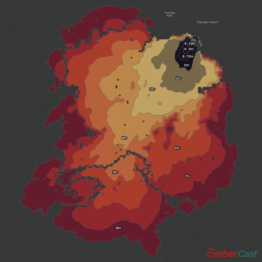
EmberCast API (SaaS) is an industry-standard, physics-based Rothermel fire spread model, that runs on the latest national-level LANDFIRE data, which provides detailed information about vegetation, fuel types, and topography. EmberCast API aims to make wildfire modeling accessible through minimal user inputs, a simple design, and clear, fast results. 
 
The model is calibrated to run under extreme wildfire conditions, including dry fuels and high ember production potential. It provides a comprehensive tool that creates a scientifically informed visual to understand extreme wildfire growth potential in a specific geography.
EmberCast API

Each colored polygon represents the potential hourly growth (without suppression).

Each point represents a structure classified with a loss probability shown in a red, orange, yellow, blue (high to low) color scheme.

Structure Risk Probability

We use machine learning (ML) to predict the relative loss and survivability probabilities for individual structures from a wildland fire event.

Comprised of a set of factors, our models can be used for the tactical placement of protective assets during a fire event, as an evaluation method for regional mitigation efforts, or as an assessment of structural risk.

As of today, we have data available for over 3 million structures across the state of California.

OUR VALUES

Operate with integrity

We won’t go to market with a product or service unless we have confidence in its ability to provide accurate results. From how we engage with our clients to the solutions we produce; integrity underpins everything we do.

A human-centric approach

Our way is different, and we mean it. We put humans at the center of everything we do, including the methodology we use to assess the impacts of wildfire on people and property. We use our firsthand experience as emergency responders to understand how fires begin and the key variables that influence them, which leads to the development of more effective mitigation solutions.

Create solutions for scale

No two communities are alike. We aspire to create products and services that are able to account for location-specific conditions to help the greatest number of people.

Drive understanding and decision-making

We give governments, communities, and partners knowledge about at-risk assets, fire probability, fire propagation, and more. By doing so, we equip them with the information needed to develop approaches that, over time, build resilience.

Equitable access to data

For too long, good decision-making data has only been in the hands of a few. For us, no partner is too big or small. We believe more action could be taken if risk were better understood. We make our tools available to partners and communities of all sizes to expand access to information that can help lower the number of structures and lives lost to wildfires.

BECOME A CUSTOMER