Products
Lorem ipsum dolor sit amet, consectetur adipiscing elit, sed do eiusmod tempor incididunt ut labore et dolore magna aliqua. Ut enim ad minim veniam, quis nostrud exercitation ullamco laboris nisi ut aliquip ex ea commodo consequat. Duis aute irure dolor in reprehenderit in voluptate velit esse cillum dolore eu fugiat nulla pariatur.
Democratizing fire modeling.
Active fire UAS modeling.
Product #1
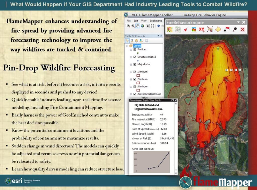
Focuses on Fire Departments, Local Governments and News Media.
Product #2
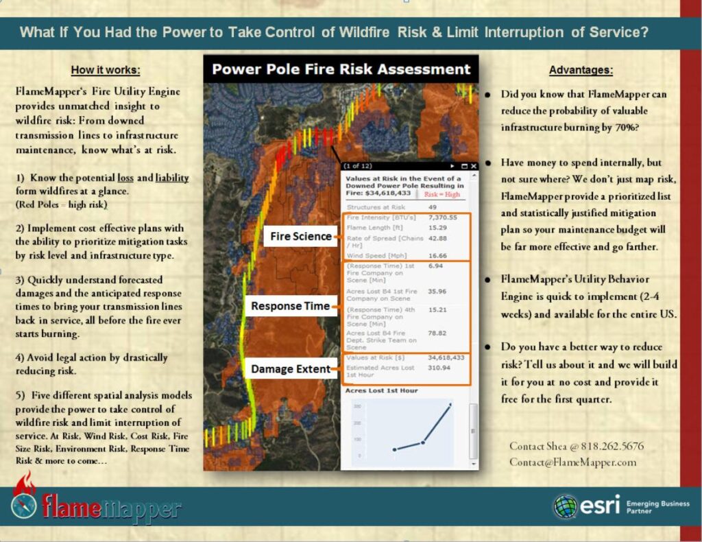
Focuses on Electric Utility Sector/ Industry.
Product #3
Mitigation Mapper: The Mitigation Mapper is a simple, yet effective tool that ensures the money you spend makes a difference. Our tools allow us to virtually test a proposed mitigation (for effectiveness) before the mitigation project ever breaks ground.
Product #4
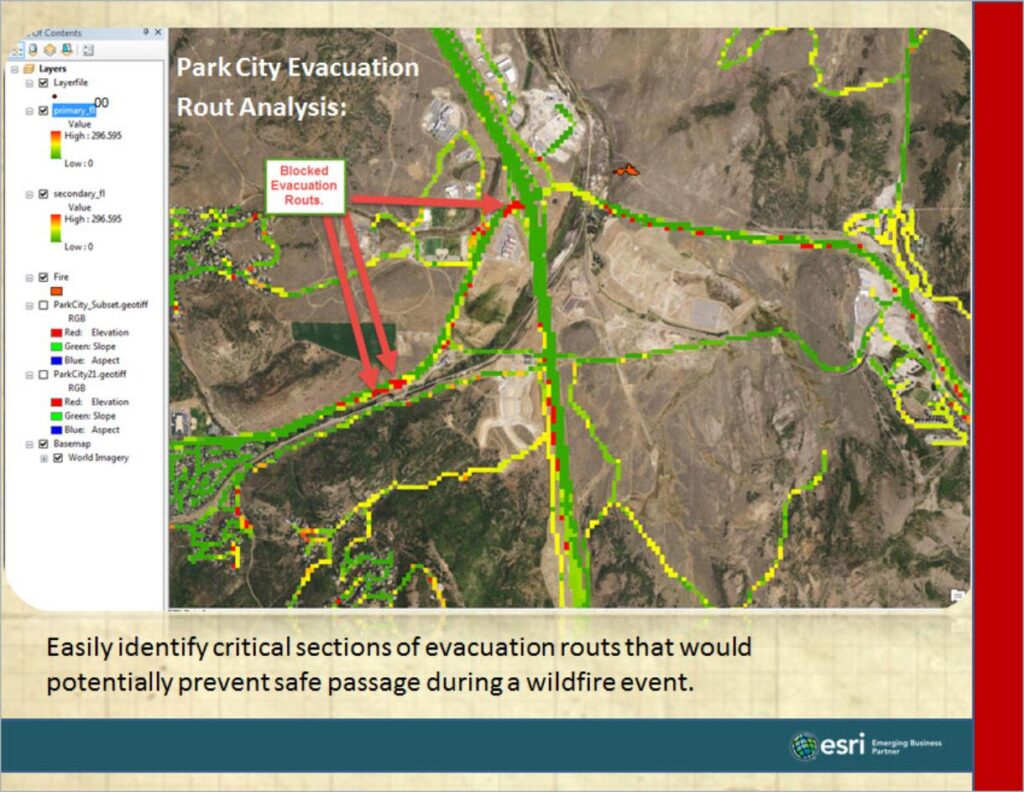
Evacuation Route Safety. Easily identify critical sections of evacuation routes that would potentially prevent safe passage during a wildfire event. Then use Mitigation Mapper to introduce a mitigation plan to ensure safe passage during a wildfire event.
Product #5
Home Assessment Reports. We “Virtually” Burn Your Entire Property, at multiple wind angels, which provides an enhanced understanding of how fire will behave on your property. Our reports help everyone better understand the vulnerabilities and risks your property faces, and what should be done to mitigate those risks. This includes an in person 2hr walk through and detailed report that we recommend taking back to your insurance company. Schedule a walk through by contacting us at: contact@flamemapper.com | If you are not interested in a report, then our virtual assessment and 2hr walk through may be just what you are looking for.
Product #6
Targeted Community Alerting and Monitoring (Active Fire Alerting). A new fire was just reported, chances are you want to know how big, how much time you have and if it is coming your way, Right? PulsePoint, and Twitter are great resources, however, if you are looking for more targeted information to help you determine how you, or your loved ones may be impacted, we can help. Our ability to “Virtually” Burn active fires and compare them against real fire perimeters has give us tremendous credibility in the industry. This is a paid virtual monitoring service, sent out through email that includes detailed graphics and recommended actions that should be taken based on near-real-time fire conditions. We find that this services is popular with HOA’s, Fire Wise Communities, Fire Safe Councils, or even a small group of home owners in remote locations: Please contact Shea at shea@flamemapper.com to learn more, or to be connected with customers raving about this new service.
FAQ
The entire United States is currently available. We currently build out data for other countries on an as needed bases.
Not at all. Many organizations qualify to get the technology at a reduced, or subsidized cost to the organization, or department.
As fast as you would like it to. Available on Arc Desktop, a web mapping API, ArcGIS Portal or AGOL.
This is a revolutionary propitiatory technology that we have chosen not to showcase on the site at this time. Please contact us if you would like a live demo.